How to use CubeNexus.ai
Thank you for using to CubeNexus.ai !
This guide will help you get started with our platform. Follow these steps to upload your data, query it, and manage your account effectively.
CubeNexus.ai is a platform designed to help you analyze and visualize your data using natural language queries. It allows you to upload datasets, query them, and visualize the results in an intuitive way. This platform leverages our proprietary TULSA system, which processes and structures your data in a unified datum for efficient querying and analysis.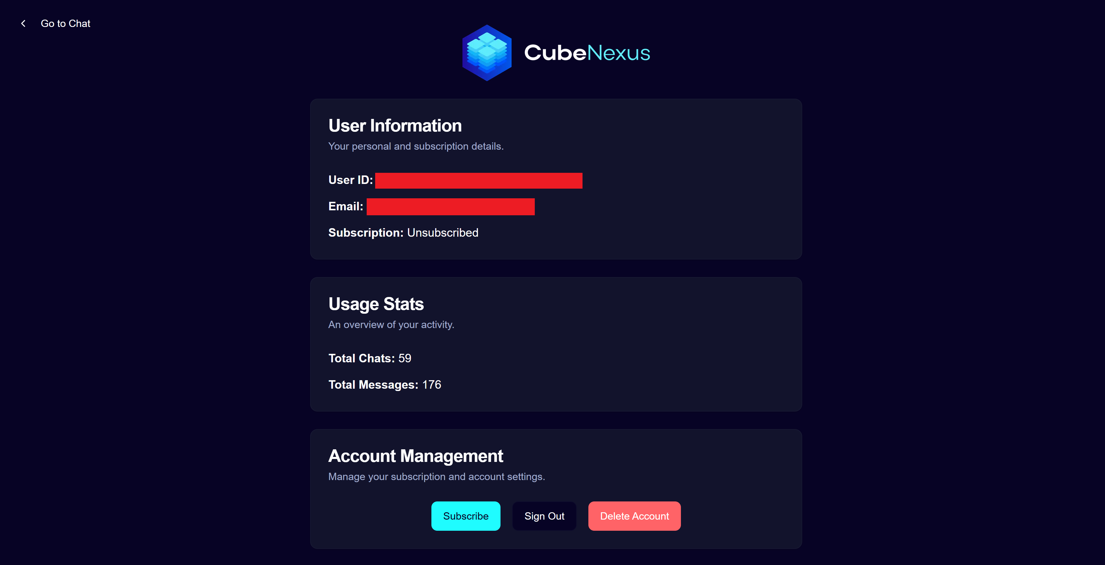 The account page lets you view your account information (usage, ID), subscribe or unsubscribe to a paid plan to unlock full access to our platform, and delete you account. It can be accessed from the user menu at the top-right on the main chat page. Payment information is securely managed by our third-party provider Stripe, and is not stored by CubeNexus.
Here is what happens to your data when you delete your account:
This guide will help you get started with our platform. Follow these steps to upload your data, query it, and manage your account effectively.
CubeNexus.ai is a platform designed to help you analyze and visualize your data using natural language queries. It allows you to upload datasets, query them, and visualize the results in an intuitive way. This platform leverages our proprietary TULSA system, which processes and structures your data in a unified datum for efficient querying and analysis.
1. Uploading data
Start by uploading your data to CubeNexus.ai, by clicking the "Upload New Data" tab on the data panel that shows up when accessing the main chat page. Currently, CSV files are supported. You can also provide attachments to the LLM later on. Once uploaded, your data will be processed and structured using our TULSA system.
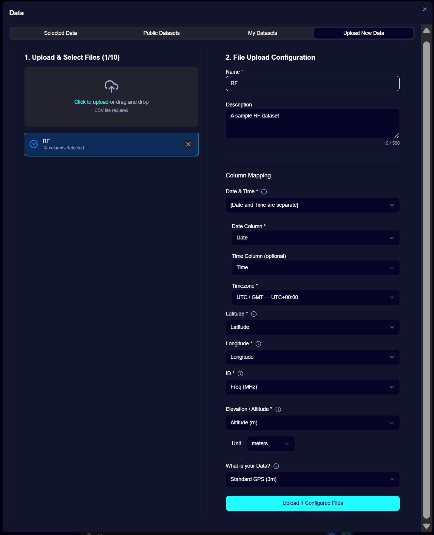 Let us know how to parse the dataset by providing the coordinate system, the time zone, and by mapping your dataset's columns to Date, Time, Latitude, Longitude, Elevation, and the ID.
Different date and time formats are supported, including joined or separated date/time columns, which you can specify on the "Date & Time" field.
The ID is typically the field identifying the acquisition device. Subsequent analyses will be based on this ID, allowing you to query data from specific devices or across all devices. Therefore, the ID choice depends on how you want to query your data later on.
Altitude is a fundamental component of the TULSA system, as it allows us to provide a truthful location of your data. If altitude is not available form your data, we provide an altitude computation service (currently capped at 20,000 rows per user per month). Specify whether you would like to use this service on the Altitude field, otherwise specify your altitude column.
Let us know how to parse the dataset by providing the coordinate system, the time zone, and by mapping your dataset's columns to Date, Time, Latitude, Longitude, Elevation, and the ID. Different date and time formats are supported, including joined or separated date/time columns, which you can specify on the "Date & Time" field.
The ID is typically the field identifying the acquisition device. Subsequent analyses will be based on this ID, allowing you to query data from specific devices or across all devices. Therefore, the ID choice depends on how you want to query your data later on.
Altitude is a fundamental component of the TULSA system, as it allows us to provide a truthful location of your data. If altitude is not available form your data, we provide an altitude computation service (currently capped at 20,000 rows per user per month). Specify whether you would like to use this service on the Altitude field, otherwise specify your altitude column.
2. Querying your data
CubeNexus lets you query your data using natural language and visualize it.
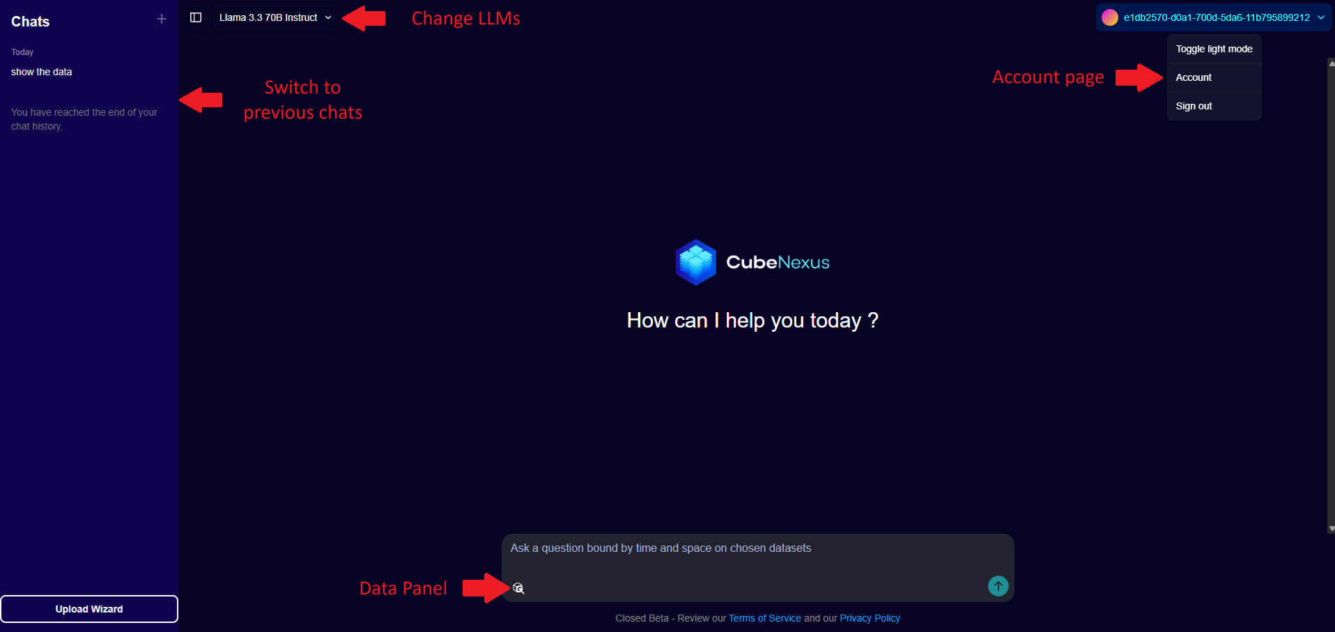 To select which datasets you would like to analyze, select them in the Data Panel which shows up when you open the page, open a new chat by clicking the + New Query button, or by clicking the cube icon in the chat box.
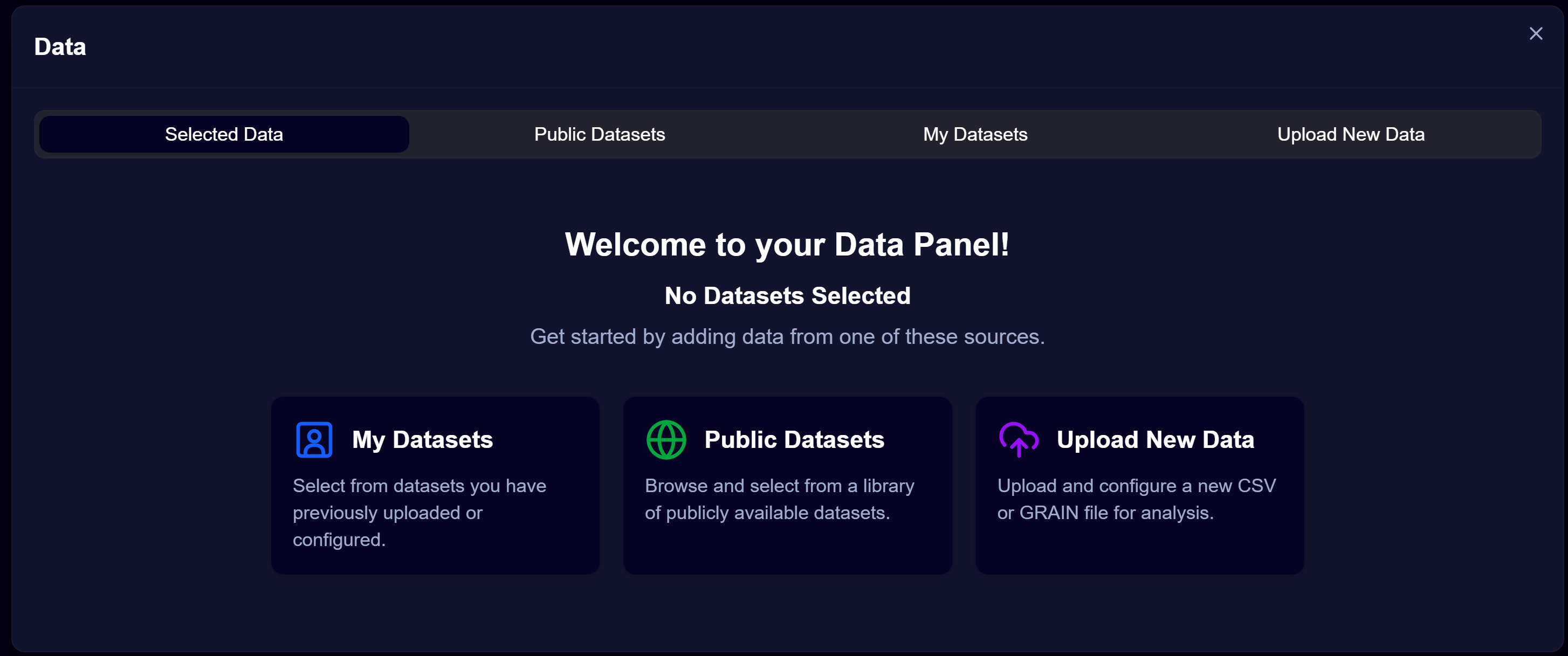 Once your datasets have been uploaded, they will show up on the My Datasets page
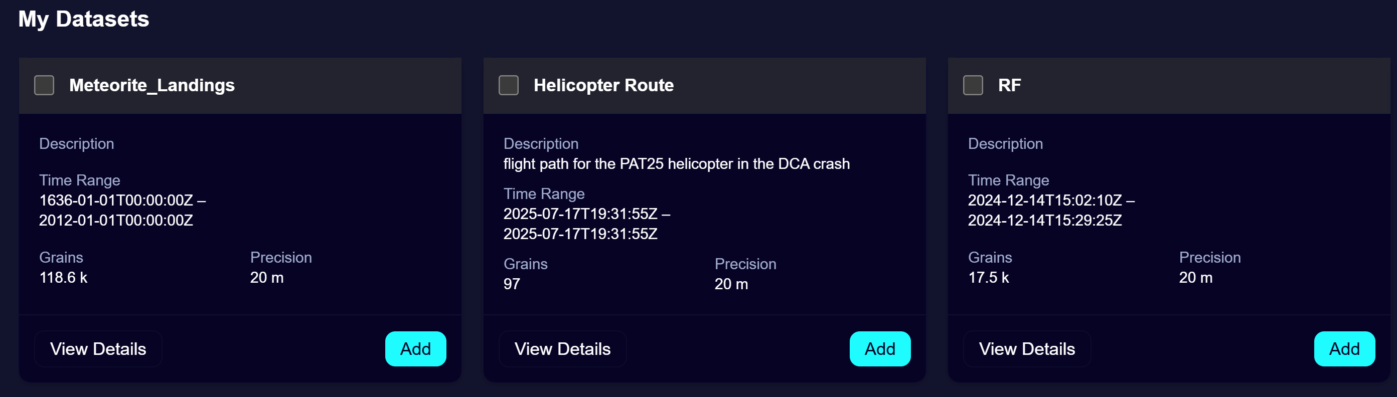 This page lets you see various insights about your data that were computed during the parsing process, including the final size in grains. You can edit your dataset title and description (to provide context to the LLM at query time) by clicking the "View Details" button. You can also delete any dataset you uploaded at any moment in the View Details page.
When you click "Delete" on a dataset, any trace of it (the data itself and its metadata) will be deleted from our system, and you will no longer be able to query it unless you upload it again.
Select all or part of your datasets by clicking the "Add" buttons. The selected data will show up in the "Selected data section" of the Data Panel. Once you have selected the datasets you want to query, click the "Start Prompting" button to close the data panel and access the chat page.
To select which datasets you would like to analyze, select them in the Data Panel which shows up when you open the page, open a new chat by clicking the + New Query button, or by clicking the cube icon in the chat box. Once your datasets have been uploaded, they will show up on the My Datasets page This page lets you see various insights about your data that were computed during the parsing process, including the final size in grains. You can edit your dataset title and description (to provide context to the LLM at query time) by clicking the "View Details" button. You can also delete any dataset you uploaded at any moment in the View Details page. When you click "Delete" on a dataset, any trace of it (the data itself and its metadata) will be deleted from our system, and you will no longer be able to query it unless you upload it again.
Select all or part of your datasets by clicking the "Add" buttons. The selected data will show up in the "Selected data section" of the Data Panel. Once you have selected the datasets you want to query, click the "Start Prompting" button to close the data panel and access the chat page.
3. Data, subscription and account management
The account page lets you view your account information (usage, ID), subscribe or unsubscribe to a paid plan to unlock full access to our platform, and delete you account. It can be accessed from the user menu at the top-right on the main chat page. Payment information is securely managed by our third-party provider Stripe, and is not stored by CubeNexus. Here is what happens to your data when you delete your account:
- All your uploaded datasets along with their metadata will be deleted
- Your account information will be removed from our database
- Temporary files tied to your LLM/Visualizer requests will remain in our system internally, but will be deleted after 7 days like other similar temporary files.
- You will no longer have access to the platform unless you create another account